Our current data, by the way, is:
Date/Time: 9/30 1225 PDT
Position: 42D 24.5N 129D 27.7W
COG/SOG: 125T @ 2.7 kts
Wind: N 25-30
Seas: N 12-14 ft
Sky: 100% cloud cover, occasional rain
Friday, September 30, 2011
News from the Cocky Ones
This is the front that just keeps giving! We currently have complete choice of direction that we travel - as long as it's south. We have tried southwest and southeast. They are both similar, but after a couple of tries we have again chosen southeast. We are still sailing under stays'l only. Maybe when the wind abates enough to hoist the storm jib we can choose a better course. For now, though, we are warm and dry in the cabin, waiting for a change in weather.
Position Update 9/30
The California / Oregon border is not our friend. The last few times we have tried to cross it together, on land or at sea, it has hammered us with big winds, big seas, or lots of snow. Thankfully, we don't have snow this time. I'm cold enough as it is. But, the wind that was supposed to briefly pick up as the cold front moved over us has maintained its 25-35 knots for the last 12 hours. According to the GRIB weather files that we download on our radio, we may see this kind of wind for a few days unless we can figure out how to move out of its way. Sailing with just the stays'l up at the bow has not been effective. We have been moving at about 2 knots in a southeasterly direction all night, which is not the way to get to Friday Harbor. Fortunately, we are moving so slowly that our mileage to Friday Harbor has not changed, just the direction has changed by 2 degrees. Daylight is just now breaking, and we are pretty tired from yesterday's efforts. But, we have been taking turns resting all night and we should be able to figure out a better sailing arrangement soon, when our heads are clearer and the day is brighter. In the meantime, we'll just be taking in the scenery along the California / Oregon border. We have the diesel stove on, so we are warm and toasty below decks where we can watch the radar and other instrument data on the computer. All is mostly well on board.
Our current data:
Date/Time: 9/30 7:45am PDT
Position: 42D 28.9N, 129D 41.5W
COG/SOG: 103T @ 2.5 kts
Wind: NE 22-29 kts
Seas: NW 6-10 ft
Sky: 100% cloud and light rain
Thursday, September 29, 2011
Frionted!
Ok, that last post was not intended to be a prediction, but that's what it was. The yankee jib is now fully shredded. A bunch of new work for Cynthia, since we really need it for the upcoming lighter wind. This front was pretty violent, and laid Columbine on her side when it hit. We had doused the mizzen, but still had up the full main and the now-ruined yankee jib. We had also switched the music to Nine Inch Nails blaring on the inside stereo (that's our official storm music). We are now sailing under stays'l only, waiting for the storm winds (and driving rain) to pass. By the way, we are now dialed in enough that everything below, in the cabin, stayed in place during this event.
We have been dissecting this frontal encounter, trying to learn from it what we need to do differently. So far we think we need bigger, stronger headsails. Columbine seems to need a lot of sail area to get going, but the present lightweight yankee jib can't handle it when the wind rises. We need it to be both big and strong for these stormy ocean sailing conditions.
Another option would be to go with a roller jib, but we have been reluctant to do that. For one, they are very expensive. We are also, as Cynthia pointed out in an earlier post, weird northwesterners, so we tend to do things the hard way. This definitely qualifies. Let's just cut another set of facets into this square stone wheel.
Anyway, the front has passed, and we now have some strong upwind sailing to do. 420 nm to Cape Flattery!
We love fronts!
With the next cold front approaching, predicted to hit us this afternoon, we are now getting the wind preceding it. Winds are 20-30 knots out of the southwest, pushing us right where we want to go. We are carrying a full main, full mizzen, and yankee jib, and going 7+ knots. This is probably too much wind for the poor yankee, which is a lightweight nylon sail. We have already ripped the seams out twice this passage, and Cynthia has restitched it both times. But our working jib is out of commission due to badly worn hanks, so it's the yankee or the storm jib, which is way too small. Besides, this is fun, and we can fix the yankee soon in Friday Harbor if it blows out again.
Cynthia is still sleeping off a long night watch, during which she hand-steered for hours, and I'm rocking out to Lynyrd Skynyrd on my iPod and playing with sails trying to get even more speed.
When the front hits, the winds are expected to suddenly back to N to NNE to NE and remain 20-25 knots. That is bad for us, and we will then have to change out the yankee for the storm jib and reef the main and douse the mizzen to go upwind against it. But we have been going N to NW all day, so we should have a pretty decent angle for Cape Flattery. Another front is expected to usher us through the strait Sunday night/early Monday morning. Then we'll be there!
Position Update 9/28 (9/29)
The horse is on its way to the barn. We've been trying to make way as much north as possible, without heading east, because we think that is where we can get some better wind in the next few days than we're having now. But, Columbine just doesn't seem to want to point north. She's heading straight for the Strait of Juan de Fuca. I have to go back out there now and redirect soon.
So, here's the data:
Date/Time: 9/29 3am PDT
Position: 41D 36.5N, 130D 49.4W
COG/SOG: 45T @ 4.8 kts
Wind: SE 10-12 kts
Seas: small
Sky: Cold, mostly cloudy, and dark
Wednesday, September 28, 2011
Position Update 9/27 (9/28)
"Hey! We're over 40 degrees now!" This is what Glenn told me as a lumbered into the cockpit at 4:00 this morning. I was dressed in 3 layers of polar fleece under my foul weather gear. My wetsuit booties are on my feet and I have some giant blue vinyl fishing gloves covering my hands. The only thing you can see of my skin is my nose. "Hmmph. It doesn't feel like it's over 40 degrees," I think. Oh. He was talking about our position.
Our current data:
Date/Time: 9/28 6am PDT
Position: 40D 09.9N, 131D 30.4W
COG/SOG: 340T @ 4.5 kts
Wind: NE 8-11 kts
Seas: NE 2-4 ft + W 8-10 ft
Sky: Clear, and very cold!
Monday, September 26, 2011
Position Update 9/26
It's all or nothing for us when it comes to wind. Last night we had blasting wind, so much that we couldn't put up much of anything for sails. Tonight it's back to 5 kts of wind and us barely drifting along with our biggest sails up. Neither situation is ideal for making the big speeds that we love so much. This light air is expected to continue through tomorrow before another front bumps up the wind again. Oh well, it was a lovely sunset and now it is a clear night.
We used the quiet time today to get a lot of repairs done. Cynthia re-sewed some sail slides on the mainsail: one was broken and several others were mostly chafed through. All better now. I went up the mast and replaced the halyard for the radar reflector - it had chafed through and the reflector had come crashing to the deck. Cynthia put some sail repair tape on a couple of spots on the mizzen sail. I repaired a nearly chafed-through control line for the windvane, and reorganized and secured half of the engine room storage. We'll have to come up with more to do for tomorrow.
Our current data:
Date/Time: 9/26 6pm PDT
Position: 38D 50.7N, 131D 52.7W
COG/SOG: 045T @ 3.0 kts
Wind: NW 5-8 kts
Seas: NW 2-4 ft
Sky: Clear
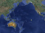
Note: Our position, in practical terms, is 70 nm north and 440 nm west of San Francisco. We are 640 nm southwest of the entrance to Juan De Fuca Strait. Following our current route, we are 754 nm from Friday Harbor.
Sunday, September 25, 2011
Position Update 9/25
Ok, we found the wind! We are currently running under storm jib only, and still making 5.5 kts. We are now even in latitude with San Francisco, and about 500 nm west. Our electronics still show an arrival in Friday Harbor on October 2 or 3. We have only 873 nm to go.
Date/Time: 9/25 2100 HST (midnight PDT)
Position: 37D 36.4N, 133D 18.2W
COG/SOG: 055T @ 5.5 kts
Wind: SW 30-35 kts
Seas: SW 8-10 ft
Sky: Mostly clear
Watches and Watchkeeping
What is a watch and what do we have to do during it? First off, legally, all vessels must maintain a proper watch at all times (24/7) when underway. This also makes sense from a safety perspective as well, and most cruising sailors adhere to this.
We have settled on a three-hour watch schedule during the night. This schedule becomes more flexible during the day, depending on work that needs to be done. On our trip down from Seattle to San Diego, years ago, we did four-hour watches, and found them too long and tiring. Three hours seems to work best for us. But that means that we can never get more than three hours of sleep at a time. This doesn't seem like much sleep, but to put it into perspective, single-handers (those who sail solo) must limit their sleep to 15-minute intervals!
So what do we do on watch? When things are going smoothly, the windvane is steering the boat and the wind is relatively steady, all we have to do is, well, watch. That is, maintain a visual and electronic lookout for other vessels or obstructions. At night we watch for the glow of lights, and periodically look on the chart plotter for AIS targets (this would be other vessels transmitting this data), and occasionally turning on the radar to look for things that don't transmit AIS data, such as a runaway buoy, for example. When something shows up, the watchstander has to monitor it and take evasive action if necessary until it is past.
When things are going less smoothly, the watch person might really have their hands full. Usually this occurs because of shifty winds or really light conditions that the windvane might not be able to cope with. In this case it might call for hand steering. If the winds change enough, they must readjust the windvane or sails to compensate. During some watches, this process is continuous and can get to be pretty tiring. If conditions change significantly enough, the sleeping person might have to be awakened to help change sails. During all this other activity, the person on watch must also continue to watch.
At night, when not on watch, the preferred activity is to sleep - you only get three hours! During the day, it could be relaxing with the guitar, playing games on the iPod, writing blog posts, or doing one of the many tasks that are always required. Depending on how the previous night went, it also might be that you just get some more sleep.
Saturday, September 24, 2011
Position Update 9/24
Today has been both frustrating and exhilarating. Last night the winds went very light and shifty, and it was a lot of work just to keep the boat moving. Tonight is the same, with boat speeds between 2 and 4 kts, in various directions. During the day, though, we averaged better than 6 kts. Anyway, here is our 9pm data:
Date/Time: 9/24 2100 hst
Position: 36D 25.4N, 135D 31.4W
COG/SOG: 065T @ 3.8 kts
Wind: NW 8-10
Seas: NW 4-6 ft
Sky: 15% cloud cover
----------
radio email processed by SailMail
for information see: http://www.sailmail.com
Friday, September 23, 2011
Columbine Position Update, 9/23
After a really fast day of sailing (6-7.5 kts), in winds of 30-35 kts, the cold front we had been using for all that wind passed over us with the wind suddenly shifting to the northwest. We are still going pretty fast, but expect the wind to moderate soon and become more steady, less gusty. Life is still pleasant onboard, but Nemo is unhappy he had to find a new position since the boat is heeled over the other way now.
Our current data:
Date/Time: 9/23 2005 HST (11pm PDT)
Position: 35D 09.0N, 137D 15.8W
COG/SOG: 050T @ 6.0 kts
Wind: NW 17-25 kts
Seas: SW 5-8 ft
Sky: 100% cover, rain
Thursday, September 22, 2011
Position Update 9/22 - Day 30
Conditions were much stronger today, with winds 25-30 kts and seas up to about 12 feet, but we have been very comfortable onboard. We spent most of the day outside, chatting and getting some little projects done. Had a delicious coconut curry with tofu for dinner. It's easier to do a lot of things now that we aren't heeled over 20 degrees all the time. Now we are riding mostly flat (thanks to our downwind course, finally), but now we get a continuous rolling motion and an occasional big roll when the waves combine just so.
At the suggestion of the WeatherGuy we have changed course to a more easterly direction to avoid some stronger weather that would have enveloped us on our previous course.
Our current data:
Date/Time: 9/22 2100 HST
Position: 34D 20.9N, 139D 50.1W
COG/SOG: 080T @ 5.5 kts
Wind: SW 20-30 kts
Seas: 8-12 feet combined
Sky: 20% cloud cover
----------
radio email processed by SailMail
for information see: http://www.sailmail.com
Wednesday, September 21, 2011
Position Update 9/21 - Day 29
This morning we decided that we had to begin sailing only despite the still-light winds. We want to conserve our remaining fuel, which is still quite a bit, as much as possible. Plus we were tired of hearing it 24 hours a day.
So we went to work on some of the systems that make us go faster in lighter winds, and especially downwind systems. For example we completely rerigged the spinnaker pole so we could pole out the jib. We also tweaked the windvane some more so it is more sensitive, and replaced all the control lines. And added a new preventer to the main boom. I think there's more, but I can't think of them right now. The end result is that we have been sailing all day at close to our motoring speed and with easier steering effort on our part.
Our data for today:
Date/Time: 9/21 1832 HST
Position: 33D 11.1N, 141D 45.0W
Course/Speed: COG 030T, SOG 3.5-4.7 kts
Wind: SW 10-15 kts
Seas: W 4-6 feet, occasional 8 feet
Clouds: 60% cover
Tuesday, September 20, 2011
Position Update, 9/20 - Day 28
We are still motoring slowly northwest, waiting for the expected wind to hit. I think it's for real, because we are starting to get some big (6-8 foot) swell from the west. We just had a crossing with a big cargo ship, the first vessel we've seen since the equator, and we chatted on the VHF radio. He was headed to Onahama, Japan. He asked when we were expecting to arrive in Seattle and I told him October 3. He said his arrival in Japan is also Oct. 3, but I looked it up and he has 4200 nm to go and we have just under 1400 nm. What a difference a little speed makes!
Our current data:
Date/Time: 9/20 6pm HST
Position: 31D 45.3N, 142D 57.5W
Course/Speed: COG 025T, SOG 4.4 kts
Wind: SW 5-7 kts
Seas: W 6-8 ft
Clouds: 10%
Monday, September 19, 2011
Rock 'n Roll!
Tomorrow we start to rock 'n roll. We have been motor sailing in light winds for the past two days. But that is about to change. Predicted winds go to 25-30 tomorrow, and from the GRIBs I see up to 40kts. But, they will be pushing us from behind for a change. So, the ride should be much more comfortable than if we were facing those headwinds. Forgive us in advance if we don't have verbose blogs in the next couple of days. We may be tired.
Our current data is:
Date/Time: 9/19 1800 HST
Position: 30D 21.5N, 144D 25.6W
COG/SOG: 050T, 5.0 kts
Wind: SE 7-9 kts
Seas: NE 1-3 ft
Sunday, September 18, 2011
Position Update 9/18
Nemo proved his superior hunting prowess this morning by nabbing his own breakfast. I thought he had just been lounging lazily for the last few weeks on the port side setee, when really he had been scheming, waiting for the right moment to pounce on the stash of emergency Tahitian kitty kibbles in the forward locker. I wonder if he had anything to do with the leaking windlass mounts that lie directly above this locker. Glenn finished fixing that leak this afternoon, but the locker has been left open for the last few days so that we could periodically mop it out. As Glenn was sleeping off his watch this morning, and I was outside hand-steering in light winds, Nemo took his opportunity to literally tear into the package. When I came below to wake Glenn for his next watch, I was hit by an overwhelming scent of Kentucky Fried Chicken. I'm pretty sure we're still thousands of miles from the nearest KFC, so this smell seemed a distinct oddity. If it weren't for the smell... well, and the racket that Nemo was making with his recent kill... he would have gotten away with it.
Today has been a continuation of the beautifully sunny, but calm, weather we saw yesterday. We've been motorsailing at over 5 knots all day and are starting to veer northeast again toward Seattle as the winds clock around toward the east, and even southeast!
Our current data are:
Date/Time: 9/18 1800 HST
Position: 28D 58.2N, 145D 34.8W
COG/SOG: 020T, 5.0 kts
Wind: E 5-7 kts
Seas: NE 1-3 ft
Saturday, September 17, 2011
Position Update 9/17
Today has been a needed contrast to yesterday... the winds lightened some and the seas dampened. We are still making way between 4.5 and 5.0 knots, but the sailing is much calmer. Sunny skies and light winds made today a perfect day for doing laundry (woohoo!). We had made extra freshwater the other day with just this kind of occasion in mind. All of our sweatshirts are very salty from all the spray we've been taking in the cockpit for the last week. We know we'll want those warm and dry as we get further north, so it's important that I was able to get the salt out of them today. I even applied a little soap so they smell nice too!
Unfortunately, tonight is looking like we'll have squalls in store for us again. I guess it's time to crank the tunes again, but I'm getting tired of Nine Inch Nails. Maybe, Alice in Chains instead? Hmmm.
Our current data are:
Date/Time: 9/17 1800 HST
Position: 27D 14.6N, 145D 42.7W
COG/SOG: 350T, 4.8 kts
Wind: NE 8-10 kts
Seas: NE 3 ft
BTW: Yesterday's longitude should have read 145D 34.4W. Woops.
Friday, September 16, 2011
Position Update 9/16: Day 24
We had a much tougher night last night due to a continuous stream of storms that swept over us. Today we are much more tired than usual because of the additional work that storms require - sails up/down, reefs in/out, all night long. Today we got a break and have had pretty decent winds and no squalls!
In our weather update from the WeatherGuy we received a significant course change - we will begin heading more or less directly toward Seattle. This knocked over 300 nm from our remaining distance. on the other hand we have some really light wind days ahead. After the past couple days of storms, we are looking forward to that. Time to get some laundry done and some other chores that we can't do in heavier wind. After inputting the new route into our plotter, it still estimates our arrival time within a day or two of the previous estimate - still Oct 1-4 timeframe.
Our current data is:
Date/Time: 9/16 1800 HST
Position: 25D 21.6N, 125D 34.4W
COG/SOG: 350T, 5.6 kts
Wind: NE 12-18 kts
Seas: NE 6-8 ft
Thursday, September 15, 2011
Position Update 9/15
This last day has been marked with inconsistent winds... not enough, then way too much from a totally different angle. These winds are squall-driven. Before the squall arrives, the wind backs way off. Then, with the arrival of the squall, the wind can shoot to as much as 20 knots and you're never quite sure which direction it will come from. The most recent squalls have been unlike any we have encountered so far in that they seem to fly by us - on a mission, if you like. Others we have seen previously seemed to creep slowly up on us and then dog us for quite a while - sometimes for over an hour. I'm not sure which I prefer, really.
So, in an attempt to moderate the effects of the squalls, we motor-sailed most of the day today. Consequently, we had a surplus of power which we used initially to make some freshwater and then we decided to have a small dance party to liven our spirits. We cranked Nine Inch Nails which seemed to be an appropriate soundtrack to the squally day. Nemo excused himself to the bed while Glenn and I performed modern interpretive dance moves which would have been much more difficult on a stable land-based platform.
Our current data are:
Date/Time: 9/15 6:07pm
Position: 23 deg 29.2N, 145 deg 23.7W
Wind: ENE 14-18
Seas: NE 4-6 ft
Wednesday, September 14, 2011
position Update 9/14
We experienced a variety of sailing conditions today, but for most of the day it was pretty strong winds and bigger seas - winds >20kts and seas 6-8 feet. We adjusted our course a little to go more west, as was suggested by the WeatherGuy and verified by the GRIB wind data that I downloaded. So our speed has increased a lot, and our remaining distance has increased. It still looks like we will make landfall in early October. Our electronics estimates between September 29 (unlikely) and October 3 (much more likely). But there is a lot of ocean between here and there. We will start posting updated arrival dates regularly.
Our wind today was a lot more consistent, and we changed our course some, so we have made pretty good time today. It was also a lot more comfortable ride today. Our current data is:
Date/Time: 9/14 6:14pm
Position: 21 deg 31.0N, 144 deg 54.0W
Wind: ENE 14-18
Seas: NE 6-8 ft
Tuesday, September 13, 2011
Position Update 9/13
Columbine continues to make good progress north. At the WeatherGuy's suggestion, we are now bearing a little more west, so our speed has increased. The winds have been strong all day, and are predicted to remain so for the next few days. Good for our progress, but more tiring for us.
We now have a very preliminary estimate of our arrival in Friday Harbor, where we plan to clear customs and sleep before tackling Seattle: our electronics say October 3 at ~2am. A lot can happen between here and there, so take this estimate with a grain of salt.
Our current position information is:
Date/Time: 9/13 6:08pm
Position: 19 deg 33.5N, 144 deg 23.1W
Course/Speed: COG 355T-000T, SOG 6.0 kts
Wind: NE 15-20 kts
Seas: NE 6-8 ft
Getting High in the North Pacific
No, I'm not talking about that. I'm talking about the weather. The North Pacific High is an important feature in this ocean, and this blog is about how it affects us out here sailing. First of all, a short primer on the organization of Pacific Ocean features.
Just north of the equator is a band called the InterTropical Convergence Zone (ITCZ, or doldrums). This band runs pretty much from Central America to SE Asia, and is widest near Central America. This region has generally very light winds and frequent squalls, some of them violent. Some of these squalls will grow to become North Pacific hurricanes, but in the ITCZ they are just forming and are still relatively weak. Sailors always dread the doldrums, as did we, but in our two crossings in the past six months we had pretty benign conditions.
Just north and south of the ITCZ are the two tradewind zones. These are characterized by good steady winds, both sides trending westward. In the north the trades blow from the northeast, in the south from the southeast. The trades extend out to about 15-20 degrees latitude each side. They also have some squalls, but these squalls are fast moving and not usually violent. These storms also never pass through the ITCZ - in fact, no storms form in one hemisphere and travel to the other. The ITCZ is a barrier that effectively separates the two.
Outside the trade wind zones is a lot of ocean. The primary feature of both the North and South Pacific Oceans is a permanent high pressure region. High pressure regions are known for light winds and sunny skies, while low pressure cells are associated with storms. While this is generally true, it is the association between the lows and highs that most affects us. Remember that wind is created by these pressure gradients, and the steeper the gradient (i.e. the larger the difference in high and low pressure regions, or the closer they are to each other) the stronger the wind. The trick is knowing exactly where they are so we can predict how strong the winds will be so as to avoid really strong and really light wind areas.
While the two high pressure regions of interest here are permanent, they are definitely not stationary, nor are they of consistent size or shape. You have to track them and try to predict, based on past observation and outside influences, where they will be at some future time. This is where the WeatherGuy comes in. He analyzes the big picture all day, every day, and tries to predict our best route.
Remember that winds swirl clockwise around a high, and counter-clockwise around a low. This means that, to get winds that will most help us get to Seattle, we need to pass west of the high, and then follow the winds around eastward across the top. This is the game we are playing right now - guess the future position and size of the high so we can benefit from it, and not be stuck in really light or really strong winds.
Monday, September 12, 2011
Position Update Day 20
Today's winds have been more variable, stronger then lighter, more then less favorable direction. But we have been keeping the speed up pretty well, so at least we are moving north. We were treated today to a beautiful sunrise as well as sunset, although we both agreed that last night's sunset was more spectacular. Today was also another landmark: we passed through 17 deg 35N, which is the northern reciprocal of Tahiti's latitude. So we have traveled through 35 degrees of latitude. As of noon today, we have logged 2138 nm from Tahiti. Today was also noticeably cooler for us whimps - we had sweatshirts on all day instead of just at night. And we're not out of the tropics yet!
Our position data as of 6pm was: 17 deg 43.2 N, 144 deg 14.7 W. Our wind was stronger at over 16 kts, but was NNE which is worse for us.
Ok, I'm back now. As I was writing this post the wind went up to over 20 kts and I had to go out and take two reefs in the main and ease both jibs. We seem to be better now. That's just the way today has gone. But I got a couple of chores done today - servicing the fuel filters *before* they stopped the engine, and adding a grab handle in the galley.
Heeling-Over Hotcakes
Butter is sizzling as I heat up my shallow cast-iron skillet, preparing to make hotcakes for breakfast. This has to be my favorite breakfast food, and I'm lost in daydreams of pancakes past.
The best way to eat pancakes, in my humble opinion, I learned from my Dad. Stack 'em up with butter between and a fried egg on top - over-easy so the yellow runs all over the pancakes. Add copious amounts of maple syrup, and enjoy. It's best not to look too closely at this dish as you're eating it because it has the appearance of something gone very wrong. But, it tastes sublime.
Others, I have learned, have very different ideas of what makes the ideal pancake. In college, I happened to live with a number of people who were very passionate about their pancakes. I suggested that thinner pancakes were great because 1) you can stack more of them on your plate (giving a greater surface are available for butter application), or 2) you can roll them up like an American-style crepe. My best friend, Noel, was appalled. She strongly corrected my assertion with her own view that pancakes must be thick, fluffy, and golden brown, made from scratch with real buttermilk. Yet another friend was adamant that pancakes should be made with potatoes, slathered with sour cream, and topped with tart homemade applesauce. Well, we decided to have a taste test. There was tough competition, but it wasn't really a fair contest. Noel's pancakes were such melt-in-your-mouth fluffy goodness, and so perfectly evenly browned that she won hands down.
The pancakes I'm making for breakfast today are not homemade, but from a mix. And, they will not be an even golden brown. Noel would cringe, but I am pleased. I am making my Grandma's version of pancakes, which she called hotcakes. The thick batter is poured onto a sizzling hot griddle, where they nearly instantly start bubbling up, ready to flip. The result is a dark, toasty pancake with white splotches with radiating tendrils where the batter bubbled as it hit the pan. These are the Jackson Pollock version of pancakes, and they are ideal for cooking while sailing. You can be rest assured that no matter the angle of heel of the boat, these pancakes will stay in the pan until you tell them to do otherwise. The fried egg is a much trickier accomplishment.
Sunday, September 11, 2011
Columbine Update 9/11
Today was fantastic weatherwise, with light to medium winds and mostly sunny skies and warm temperatures. The day was terminated by a spectacular sunset, with clouds accented by reds: from yellow and orange to crimson.
Our progress has remained good, with decent speed even in the light winds, and an overall good direction. We had no boat problems today. Cynthia baked bread to accompany dinner, and I worked on various projects and repairs as well as getting in some guitar time. We are now, as of last night, officially out of the doldrums, and are in fairly consistent NE winds and seas. That means we are still going into the wind and swell. We can't wait to go downwind again! We have been going upwind on a starboard tack now for almost three weeks. Right now it looks like that won't change anytime soon.
Our current position (as of 6pm) was 15D 37.5N, 144D 12.4W. Our speed has been averaging about 4.5 kts on a course of about due north. Our next waypoint is named Hawaii, because it is at the same latitude as Hawaii, 20D north, but we are almost 1000 nm east of there. We should reach that waypoint in a couple more days. Then the next one will be up close to Seattle! Right now it looks like about three more weeks or so to go, but nothing is set in stone when the weather is concerned.
Saturday, September 10, 2011
Lessons from Childhood Rollerskating
These are the lessons I learned while rollerskating as a child:
1) You will fall down, and it will hurt.
2) You will fall, specifically, on your butt.
3) If you strap a pillow to your backside, it will not hurt as much when you fall down on your butt.
4) If you don't strap a pillow to your backside, you will be sorry.
5) When you don't fall down, you'll have fun.
I find that these lessons apply equally well to sailing. I cannot count the number of times I've sat down a little quicker than expected and/or missed the seat altogether. Before I got my sealegs, I had accumulated such a mass of bruises on my thighs, it looked like a topo map of a complex island archipelago.
But, more painful and aggravating than all of these other bruises combined is a bruised tailbone. Glenn and I have both smacked our tailbones so hard they have been bruised for weeks. I suspect Glenn injured his while sitting rather quickly and unexpectedly on a winch. I bruised mine again recently when a wave leaned the boat over faster than usual, and the companionway ladder was suddenly closer than I had expected it to be as I had been preparing to brace myself against it for just such an occasion... too late.
A bruised tailbone can be so painful, it'll make you suck in breath every time you sit gingerly on a cushioned chair. Imagine, then, how often this injury is aggravated while sailing. It is surprising really how much of our time is spent sitting. And, unfortunately, most seats are not well-cushioned and we don't generally get to sit gingerly on them.
These are the times when I think back to my childhood rollerskating days, and I long to have a pillow strapped to my backside.
We are currently sailing a pleasant but bouncy course as close to due north as we can manage. Our position as of 5:30 HST is 13deg 46.3' N; 144deg 06.0' W. Our weather router has applauded our great efforts to make the 145deg W goal at 10deg N because gaining more east initially will be an advantage to us later when the winds clock around more from the north. Then, we will be losing all of that east we have gained, but it will be a much easier sail. Let's hope so.
Friday, September 9, 2011
Delayed Update
Due to technical difficulties, I wasn't able to post yesterday's blog. We had an electrical issue that had to be taken care of before we felt comfortable emailing again. That is now all fixed - thank goodness for all the spares we carry. And if it breaks again, we have still more!
The past two days have been both exhilarating and boring. We get a spell of wind for a while, and our speeds go crazy and our computed arrival times go down. Then the wind goes away and we are hand-steering and looking at far away arrival times. Overall, though, we are still making really good time despite the conditions. And we are almost completely clear of the doldrums. That should be by tomorrow morning. But they have not been unkind to us, and our passage is still going well.
Our current position is 11 deg 26.7 N, 144 deg 08.7 W, as of 1145 local time today (9/9). We are motoring due to light winds, with a speed of 5-5.5 kts, on a course of ~045T.
Wednesday, September 7, 2011
Sailing in the Doldrums
At the risk of sounding repetitive, today was an incredible day of sailing. It wasn't the weather - we are in the doldrums and facing squalls and rain several times a day. Plus we had a breakdown that had to be fixed right away, and took several hours - another bout of water in the fuel. This was important since we are still motor sailing due to the very light winds. After tomorrow we should be past the doldrums and into the northeast trades.
Anyway, what made today so awesome was the closeness we felt. We worked together seamlessly to keep the boat moving, of course, but we also clicked on another, deeper, level. Ok, so no more mushy stuff. Suffice it to say that we are getting along really well.
We have been having fantastic conditions for the ITCZ (InterTropical Convergence Zone, or doldrums). We have seen many squalls, and have gone through several, but they have been pretty mellow and most we have been able to avoid altogether. Outside of the squalls we have had stretches of pretty decent wind, and in a good direction. So we are progressing well.
Our current position (at 6pm local time) was 08 deg 44.4 N, 144 deg 58.7 W. our speed was 5.2 kts, on a course of 015T. Our next waypoint is 10 deg N, 145 deg W. As you can see from our position we have already made enough progress eastward that we have made that part of our waypoint. But we will continue to go somewhat eastward in anticipation of the northeast trade winds, which we should start seeing tomorrow night. They will not allow any further eastward progress, and will probably push us further west. So we'll take what we can get now.
Update 9/6
Okay, so this update is a tad late. Yesterday was a day full of motoring (while hand steering) with a few sails up to see if we could catch any wind. Mostly, there wasn't any. Then, last night, there was a bit too much wind. We had to reduce sail area so that the wind didn't make us lean over too much, but that also greatly reduced our speed. It's always frustrating to have so much wind available and not be able to take advantage of it. Right now we are sailing (with no motor, yeah!) at about 2 knots (boo!), but we're headed in the right direction to hit the 145deg W longitude by the time we leave the doldrums (yeah!). So, we'll take it. Glenn's sleeping off the last of his watches right now, and then we'll see about putting up some more sail because now the wind is reasonable.
Our current position is 07deg 54.7' N; 145deg 07.8' W.
Monday, September 5, 2011
Uptade for 9/5
Today has been a topsey-turvey day for sailing. We have seen everything between strong wind and light, right direction and wrong. But we have kept up and adjusted and are still making great progress. Right now we are making between 7 and 8.5 knots boat speed in a mostly east direction. How can we do that, you ask? Well, our limiting factor for boat speed is the theoretical hull speed, which is (more math) 1.34*SQRT(waterline length). While we are a 38 foot boat, and, with overhangs nearly 50 feet long overall, our speed is limited by the amount that is in the water, which, when at a dock, is 33 feet. Thus our maximum theoretical dock speed is 7.7 kts.
Ok, that was a joke. Our maximum dock speed is 0 kts. Our maximum theoretical speed at sea when we are level is 7.7 knots. But when we heel over, our waterline length increases a lot. That is how we are able to now sail at over 8 knots. If we do the calculation the other way, to go 8.5 knots, we have to have a waterline length of just over 40 feet. Not sure if we get quite there, but we must be close.
Our progress today has been great. All day we have been in clouds and rainshowers, just prior to the doldrums, but we have continued to make both north and east progress. Our data as of 6:30 pm was: 05 deg 47.3 N, 146 deg 23.5 W. Boat speed was 7.6 knots on a course of 052T. Seas were light at 2-3 feet, which partly explains our good boat speed.
Sunday, September 4, 2011
Columbine Update 9/4
This will be another brief update to give our position data. Except that I wanted to add one thing to the posting a few days ago about knots and latitude/longitude. Regarding knots, it seems that the term should actually be called "nauts" for nautical miles per hour. But there is a possible reason for the "knots" spelling. In the past to measure boat speed there was a special board with a line attached that was thrown into the water. The lines were attached such that the board would ride perpendicular to the boat direction and would thus remain stationary in the water. The line that was attached had a series of knots in it. This way it could be used at night or in foul weather. The seaman would throw in the board and then start timing. After a specific time, the number of knots that slipped through his hands was the speed of the boat. There you have it.
Columbine has been sailing well today under progressively lighter wind as we approach the doldrums once again. We have been maintaining over six knots all day, and the wind is now only about 12 kts. Not bad for sailing into the wind! Our current position at 6:12 pm was 03 deg 41.3 N, 147 deg 07.7 W.
Saturday, September 3, 2011
Hi from the North Pacific!
We had an exceptional day of sailing today. Last night, after crossing the equator, we took down the jib and ran under only double-reefed main and stays'l. Our speed dropped to 3.5-4 kts, but it was more comfortable and we needed the rest. We kept it slow for almost twelve hours, but this morning the jib went back up, and we also steered off the wind a bit. Our speed shot up to 7-8 kts, where it stayed all day. Then we got our update from Rick, the WeatherGuy, who still wants us to go more east. He also is predicting the wind to top 25 kts tonight. So we took down the stays'l this time, and are steering more east, and our speed is back down to around 5 kts.
It looks like from Rick's data that we will enter the ITCZ (doldrums) in about a day, and will be in them for about 1.5 days. Rick says that there is very little activity there right now, way less than usual for this time of year. That's good. Activity means squalls, and we aren't fond of them.
Our current position, as of 6 pm tonight, was 01 deg 35.9N, 147 deg 04.4W. Speed was 5.0 kts, course was 000T (due north). We will try to steer a bit more east as soon as the wind lets us.
Friday, September 2, 2011
Greetings From the Equator!
The official time of crossing was 2209 (10:09 pm) local time (which also happens to be HST, or Hawaii Standard Time). This was 27 hrs 36 min after the contest posted last night at 1833. The crossing point was 147 deg 12.9 min.
So how did you do?
Columbine Update
Ok, so with the contest going, I don't think I should give our position tonight. Instead, let me just say that today we have been smokin'. We have been above 5kts since early last night, and often over 6kts. Not bad for upwind work on an overloaded boat! If you want to revise your entry, feel free. Only the last one counts. Our next post will be from the equator.
Today has also been fantastic onboard, although the wind has made hanging out in the cockpit very wet. We got all spruced up for our equator crossing celebration - washing our hair, shaving, etc. We also spent awhile in the cockpit practicing some songs for our upcoming concert. More on that later.
By the way, I think Rick, the WeatherGuy, already has the closest estimate. But he doesn't count since he has inside information and computer programs to track us. His estimate of our crossing was made on Wednesday, and looks like it will be accurate within about an hour or so.
Thursday, September 1, 2011
Contest - Win a Trip to Disneyland!
Here's the deal. In the last post I explained how to calculate distance based on our latitude and longitude. I also explained about nautical miles and knots. Based on this information, if you can calculate our time of crossing the equator the closest, you can win a trip to Disneyland.
Fine Print: You, the winner, are responsible for travel, lodging, entertainment, and park entry expenses. Well, actually you have to pay for everything - we are but poor cruisers. We can't pay for anything. But you can revel in the satisfaction of having won. So maybe the subject line should have read "Contest - Win Permission to Treat Yourself to a Trip to Disneyland." But that's just semantics, right?
Anyway, our current position data is:
Time: 6:33pm
Latitude: 02deg 22.1S
Longitude: 147deg 51.5W
COG: 025T
SOG: 5.0kts
Tips: The wind speed and direction are predicted to remain about the same for the next day or so, so our speed and course should be fairly constant. Right now it looks like we will cross at 147deg.
Now go burn up those calculators!
Latitudes, Longitudes, and Knots
Caution: Math ahead!
Every day we send out a position update that gives our current position in latitude and longitude, our course over ground (COG) and our speed over ground (SOG) in knots. But what does this all mean? And why knots and nautical miles instead of mph and miles?
First off, let's tackle latitude and longitude. You know the earth is divided up into a huge grid. Horizontally there is a slice in the middle, the equator. Then equally spaced both north and south are 90 slices each side, one degree of latitude each. The distance between each degree of latitude is equal, so if you move one degree at the equator and one degree near a pole you have gone the same distance.
Not so with longitude. The vertical lines of longitude converge at the poles, so a change of a degree at the equator is a vastly longer distance than the same change near a pole.
Now, each degree of latitude or longitude is subdivided into 60 minutes. Each minute of latitude, which is equal to any other, is one nautical mile. So, when we report that we are at 3deg 30.0S, it means we are 3*60=180 + 30.0, or 210 nautical miles south of the equator. Pretty simple, huh?
But if we are not traveling due north there is more to it. You have to take into account both the vertical (latitude) distance as well as the horizontal (longitude) distance.
Right now, since we are near the equator, one degree of latitude is the same distance as one degree of longitude, so the math is simple. Let's say we plan to cross at 147 degrees longitude. Since we are now at 148 degrees, that is just 60 nm away to the east. But we have to go the 210 nm north as well. The actual distance we will travel is SQRT(Lat*Lat+Lon*Lon). To do the math, it's 210*210+60*60=47700. The square root of this number is 218.4, which is the distance we have to go.
The same process is used to find the distance between any two points. For example, our last two reports showed our positions as:
8/30 06deg 02.9S, 148deg 21.3W
8/31 04deg 05.5S, 148deg 09.9W
The distance we traveled is (06*60+02.9)-(04*60+05.5)=117.4 (148*60+21.3)-(148*60+09.9)=11.4
117.4*117.4+11.4*11.4=13912.72 SQRT(13912.72)=117.95 So we traveled 117.95 nautical miles between these two reports.
Knots (in this context) are just nautical miles per hour.
Statute miles (like miles on your car) are almost the same length, but not quite. There are 1.1 statute miles for each nautical mile. So when the wind is blowing at 30 kts (nautical miles per hour), it is blowing 30*1.1 or 33 mph.
So that's it. That is why nautical miles make more sense at sea. Now you can calculate how far we have gone at each report, and how far we still have to go.
Subscribe to:
Posts (Atom)